I read your interview Micah. It was very interesting to hear you revealing your secret surf forecast link. Sorry to hear you lost your forecast tool. I think forecasting is useful to so many people who want to be able to plan out their schedule a week or less in advance.
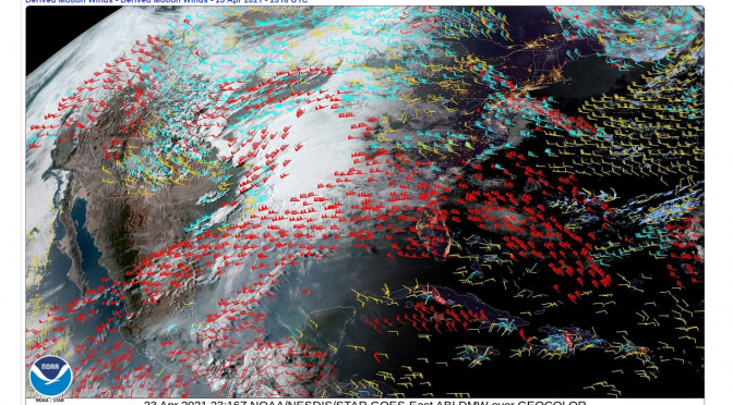
Fortunately for me, I don’t have to schedule much of anything, a haircut here, an appointment there. If you have this kind of freedom you can do what I’ve been doing lately, check the current weather in the gulf to see what the shorter term forecast holds. I bookmarked this page as my homepage: GOMEX Motion Derived Winds. I’m really starting to enjoy this tool at the present moment. I watched that last system move across the gulf and slowly drag those westerly winds across the gulf. It was tough seeing those 25 knot winds blowing in the gulf and see so little show up on the beaches. I check this motion derived winds link regularly. It’s going to tell me what’s going to happen in the next 6-12 hours. It’s actually super good at doing that from what I can tell; although I just started watching it this spring, so I haven’t had much of a chance to really see what it can show me.
After I get an idea of what’s going on in the gulf, what our winds are looking like out there, then I can check what’s actually going on at the beach. I’ll check two webcams that give me a pretty good idea of what’s going on from St. Pete north up to Tarpon Springs. I’ll check the Sunset Cam and I’ll check the Clearwater Beach cam. I don’t know if the economic community hates surfing so much in North Pinellas that they just can’t manage to put a cam at a surf spot because they don’t want to promote it, but it sure seems that way. I’ve tried to get one at Sand Key and Honeymoon. No one wants anything to do with it. So, we have to just use that Clearwater webcam. The Clearwater one is about as good as it’s going to get, as far as I can tell.
So that’s about all you need to know if you want to go surfing. Check the motion derived winds map. Then check the webcam’s when the swell looks like it’s going to get here. This motion derived winds thing is a new map on the webpage that’s housed the satellite imagery. So, it’s a pretty cool new feature that I think every surfer in the gulf can use. Check it out if you haven’t already seen it. I certainly have more thoughts on the privitization of weather information (ie. swellinfo and surfline are dogwater, and aren’t that economically viable), but I think I’ll just leave it at this. I hope everyone is finding something that works for them. See you on the next good swell in Nor-pine.
